Publications
 Partners


The South African Weather Service has warned of possible heavy downpours leading to localised flooding and short-term disruption to essential services over the North West, Free State, extreme eastern parts of the Northern Cape, extreme southern parts of Gauteng as well as the Highveld and escarpment of Mpumalanga.
Impact-based warnings
A Yellow Level 2 warning has been issued for severe thunderstorms with possible heavy downpours leading to localised flooding and strong damaging winds over the central and western parts of KwaZulu-Natal.
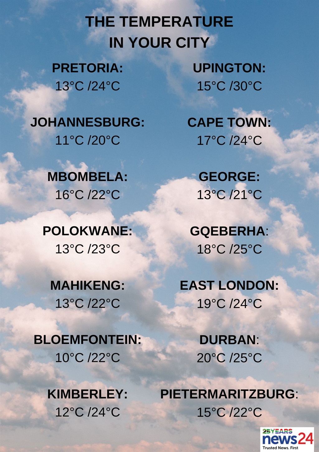
The weather in your region
Gauteng will be cloudy and cool with scattered showers and thundershowers but isolated in the north.
The expected UVB sunburn index is high.
Morning fog patches are expected in Mpumalanga along the escarpment and eastern Highveld.
Otherwise, it will be cloudy and cool with scattered showers and thundershowers but isolated in the north-east, except on the Lowveld, where it will be warm.
Limpopo can expect morning fog patches along the escarpment, otherwise it will be partly cloudy and warm but cool in places over the central parts.
Isolated showers and thundershowers are expected in the south.
Partly cloudy and cool to warm conditions are forecast for the North West, with scattered showers and thundershowers, but isolated over the far north-east.
The Free State will be partly cloudy and cool, with scattered showers and thundershowers.
Morning and evening fog patches are forecast along the coast of the Northern Cape, otherwise partly cloudy and cool to warm temperatures are expected, with isolated to scattered showers and thundershowers expected over the western parts.
The wind along the coast will be a light north-westerly, becoming light southerly in the afternoon.
The Western Cape will have morning fog patches along the coast, otherwise it will be fine and warm, becoming cloudy in the south-west from evening.
The wind along the coast will be a light to moderate north-westerly along the west coast north of Table Bay in the morning, becoming moderate southerly to south-westerly, otherwise a fresh to strong easterly to south-easterly is expected.
The expected UVB sunburn index is high.Weather & severe weather alerts for tomorrow .#saws#southafricanweather#weatheroutlook#weathersmart pic.twitter.com/R3iOyVKaTc
— SA Weather Service (@SAWeatherServic) April 15, 2024
Partly cloudy and warm temperatures are forecast for the Eastern Cape with isolated afternoon thundershowers over the interior.
The wind along the coast will be a fresh to strong easterly.
KwaZulu-Natal will have morning fog patches in places over the interior, otherwise it will be partly cloudy and cool to warm with isolated showers and thundershowers but scattered in the west.
The wind along the coast will be a moderate to fresh north-easterly, but strong at times in places south of Cape St Lucia.
The expected UVB sunburn index is moderate.